North Korea fortifies its side of the DMZ, satellite images show
I analyzed commercial satellite imagery from the United States and Europe to see how North Korea’s side of the Demilitarized Zone, or DMZ, has changed. A large scale military construction campaign is reshaping the area. Since 2024, North Korea has fortified the northern side of the DMZ. It has built tactical roads and bridges and […]
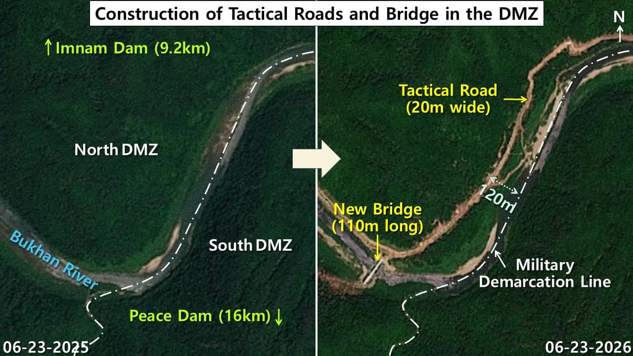
North Korea has been actively reinforcing its side of the Demilitarized Zone (DMZ), as evidenced by satellite imagery from the past few years. Since 2024, the country has constructed a variety of military infrastructure, including roads, bridges, barriers, and barbed wire fences. This has resulted in the building of a 20-meter-wide road along the Bukhan River, along with a new bridge approximately 110 meters in length. These developments are believed to be aimed at improving troop and equipment mobility within the DMZ.
Additionally, North Korea has cleared a significant area of forest, equivalent to nearly 49 times the size of Yeouido, a Seoul island covering around 290 hectares. This cleared land has been replaced by grassland or damaged terrain. The construction has eroded the DMZ's role as a buffer zone and threatens its status as an ecological reserve.
The DMZ, once a largely untouched area and a prized ecological reserve, now bears the marks of military construction. This has raised concerns about the potential for a small accident to escalate military tensions, given the already tense inter-Korean relations. To monitor these developments, continued satellite observation is deemed necessary.
Comparing satellite images from U.S. commercial operator Planet Labs, the analysis confirmed the construction of the new tactical road and bridge along the northern bank of the Bukhan River. The road connects to a parallel section roughly 120 meters from the Military Demarcation Line (MDL), which marks the boundary of the DMZ.
The land use changes inside the DMZ have also been analyzed using data from the European Space Agency's Sentinel-2 satellite. Since 2024, North Korea's construction activities have resulted in the clearing of a large swath of forest, equating to about 49 times the size of Yeouido. This shift has been accompanied by an increase in grassland, which now makes up 47.4% of the DMZ's land cover, surpassing forest cover at 47.0%.
The remaining land cover includes 3.7% cropland and just 0.3% artificial structures, primarily consisting of civilian settlements like Daeseong-dong and Kijong-dong, and a few military facilities.
Written by urgent.news from Daily NK's reporting — not their text. Machine-written — may contain errors; check the original before relying on it.