Why Channel Steepness Might Not Always Be What You Think it to Be
Channel steepness is a popular metric in most studies of tectonic geomorphology, but the simple and convenient method of defining channels in the first place may have overlooked a serious pitfall.
Determining where a river channel begins and ends may not be as straightforward as it seems, according to a recent study published in the Journal of Geophysical Research: Earth Surface. Researchers have discovered that the steepness of channels, often used as a key metric to understand river erosion in response to tectonic uplift, may contain an unintended influence from adjacent hillslopes.
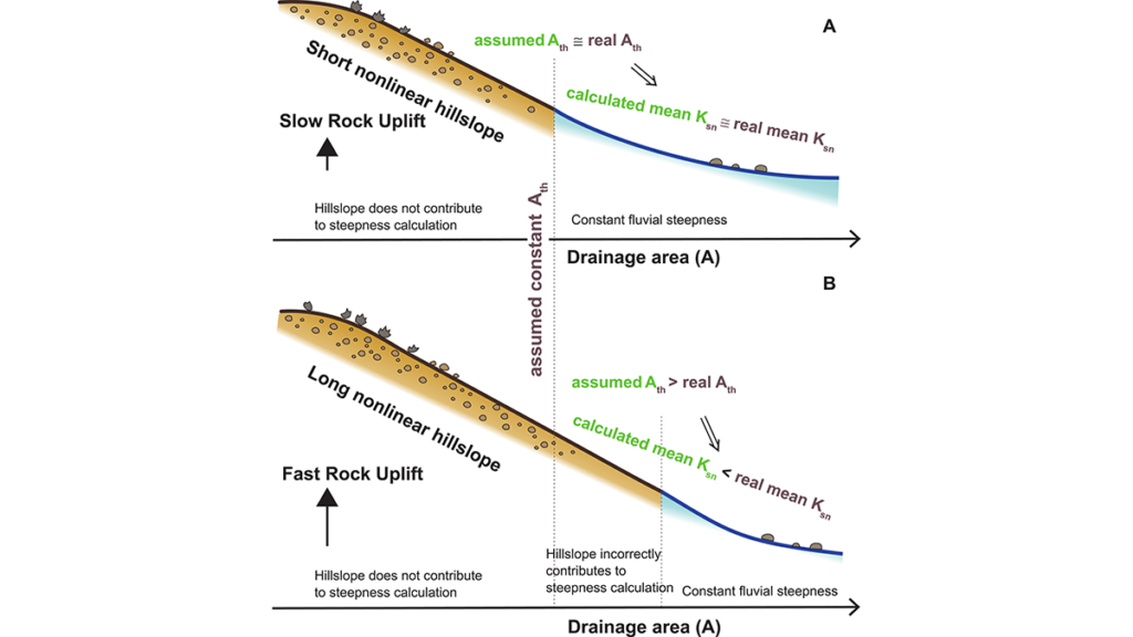
Traditionally, the boundary between hillslopes and river channels has been established using a fixed contributing catchment area. This method allows scientists to calculate local steepness as a measure of how rivers incise into the landscape. However, the new study by Fox, Goren, and Adams [2026] suggests that this approach could be flawed.
The authors present a numerical model that reveals the channel boundaries shift based on the rate of rock uplift. Their findings indicate that faster uplift rates cause hillslopes to lengthen, potentially extending well beyond the predetermined minimum catchment area used to define channels. As a result, the geometry of hillslopes inadvertently contaminates the measured steepness of channels.
This contamination can lead to inaccurate interpretations regarding river incision and how landscapes evolve in response to tectonic forces.
The issue becomes particularly significant when using "channel steepness" as a metric for river form and adjustment. The study suggests that what appears to be a "channel steepness" may actually be influenced by the processes occurring on the adjacent hillslopes, such as soil creep or debris flow. Consequently, the researchers urge for a more flexible approach to defining where channels begin, especially when incorporating this information into models of landscape evolution.
The findings of this study could have profound implications for how scientists interpret geomorphological data. By acknowledging the influence of hillslopes on channel steepness, researchers may be able to obtain a more accurate depiction of river dynamics and their relationship to tectonic uplift. This could lead to a better understanding of how landscapes change over time and provide insights into the processes shaping our planet's surface.
Written by urgent.news from Eos's reporting — not their text. Machine-written — may contain errors; check the original before relying on it.