Long drought: Levels, Kaub, driving ban: What is important for low water
What does a water level indicate? Why is the Rhineland-Palatinate town of Kaub mentioned so often? And when is shipping stopped? An overview of important facts about low water.
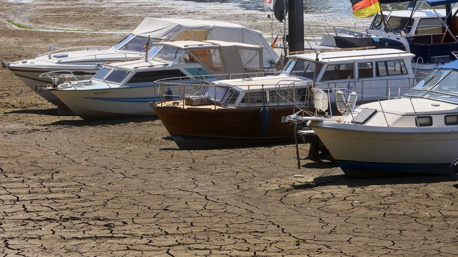
Low water levels on the Rhine, falling water levels, less cargo for ships: in these days, reports of low water levels are piling up. But what do the numbers actually mean? Why is the water level in Kaub so important - and when does low water become a problem for shipping? An overview of the most important questions and terms.
When do you talk about low water?
If a river reaches a water level that is significantly below the average value, it is referred to as low water - or a low water phase if it persists for a longer period. As the Federal Waterways and Shipping Administration (WSV) explains, fluctuating water levels over the course of the year are generally not unusual - they depend on rainfall, temperatures, glaciers, and snowmelt.
According to the Federal Environment Agency, the water level in rivers drops significantly when groundwater reserves are depleted, for example due to a dry spell, and there is hardly any more outflow from lakes. However, the agency also emphasizes that humans play an important role in this: for example, through water extraction, water reservoirs, or dams.
The situation with low water on the Rhine is becoming increasingly critical, according to experts, and unusually early this year. Late summer and autumn are typically the times when low water levels occur. At many Rhine gauges, water levels have reached historic lows in recent days.
What does a gauge reading say about the water depth?
A gauge is a fixed measuring point on the river. The gauge reading indicates how high the water is at a specific point. Measurements are taken from a fixed reference point, the so-called gauge zero point. Therefore, the gauge reading does not directly indicate how deep the river is. If the gauge reading in Kaub, Rhineland-Palatinate, is 16 centimeters, this means that the value is 16 centimeters above the fixed zero point.
For shipping, the depth of the navigable channel is crucial. The navigable channel is the area of the river where certain widths and depths are normally available for shipping traffic. There are differences depending on the section of the Rhine. In Kaub, at a gauge reading of 16 centimeters, the navigable channel is 129 centimeters deep.
Why is the Rhine such an important waterway?
The Rhine is Europe's most important waterway. It connects industrial areas in Switzerland, Germany, and other countries with the large ports on the North Sea, including Rotterdam. Although less than one in ten tons of cargo is transported via rivers in Germany, the waterways are particularly important for certain goods, such as ore, oil, chemical products, and coal.
If low water persists, transportation becomes increasingly difficult and expensive. Companies may have to reduce production. The longer the restrictions last, the more difficult it becomes to make up for lost production later. This is according to a recent study by DZ Bank. There are also various other effects: low water levels expose old munitions and slow down passenger shipping and Rhine ferries.
Nature conservationists see low water levels as an alarm signal for entire river ecosystems, for example because the oxygen content decreases with higher water temperatures.
Why is there so much talk about the Kaub gauge?
Kaub is located in the Middle Rhine section between St. Goar and Budenheim near Mainz. This river section is a bottleneck for Rhine shipping, according to the German Shipping Association (BDB). The navigable channel is less well-developed there than upstream and downstream. However, ships cannot simply jump over or bypass this section - they have to adapt to the local conditions.
The Chambers of Commerce and Industry for Rheinhessen and Pfalz also see Kaub as a bottleneck that limits transport capacities on the Rhine. At the same time, low water on the Rhine is becoming particularly apparent at the Kaub gauge readings. Before the current low water phase, the lowest measured value was 25 centimeters on October 22, 2018.
This low point is now history: the value has already dropped to 16 centimeters. According to the WSV forecast, the water level could even fall to a single-digit value for the first time in the next few days.
With regard to the forecast, the BDB warned that commercial shipping in the region would no longer be able to transport goods at such low water levels. The same applies to day-trip and cruise ship traffic. The Waterways and Shipping Office Rhein sees this point already reached for many ship classes. Most ships can no longer navigate the Middle Rhine at the current water levels. As water levels continue to fall, shipping traffic along the Middle Rhine will eventually come to a complete standstill.
When is shipping prohibited?
There is no official ban on shipping during low water. The ship's captain is responsible for safe loading and navigation, according to the WSV. How heavily a ship can be loaded depends, among other things, on the current water level and the available depth of the navigable channel. It is different with flooding: if the so-called flood mark II is reached or exceeded, shipping is suspended on the respective route section.
Translated by urgent.news. Machine-written — may contain errors; check the original before relying on it.