Mangrove loss raises flood, erosion risks along Karachi coast
Satellite images from 2000 and 2025 show mangroves near Mai Kolachi replaced by reclaimed land.—Courtesy Suparco ISLAMABAD: New satellite images from 2000 and 2025 released by the country’s space agency show a fundamental shift in land cover along Karachi’s coastal zone near the Mai Kolachi Bypass, where mangrove stands and natural tidal creeks have increasingly given way to reclaimed land and…
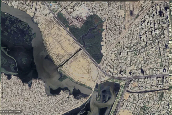
Satellite images from 2000 and 2025 reveal a significant change in land cover along Karachi’s coastal zone near Mai Kolachi Bypass. Where once there were mangrove stands and natural tidal creeks, reclaimed land and urban development have taken their place. Suparco, the country’s space agency, noted that this transformation signifies a shift from ecosystem-based coastal protection to hard, land-intensive development.
The removal of mangroves weakens the coastal system’s capacity to handle climate stress, the agency explained. Mangroves regulate coastal temperatures, trap sediments, and absorb carbon dioxide. Their disappearance eliminates an important carbon sink and disrupts hydrological connectivity, leading to increased surface runoff and altered tidal flows.
This raises the risk of localized flooding, shoreline instability, and long-term land subsidence. Mangroves are resilient and self-regenerating, providing protective benefits that improve over time. In contrast, replacing them with static infrastructure transfers climate risks directly to urban assets and communities. Senator Sherry Rehman, head of the Senate Standing Committee on Climate Change, declined to comment, while Karachi Mayor Murtaza Wahab did not respond to inquiries.
Climate policy specialist Mohammad Saleem Shaikh emphasized that Pakistan must safeguard its mangrove forests and tidal creeks, stressing that their destruction endangers coastal populations, livelihoods, and economic stability. Shaikh cited Suparco’s satellite data showing changes along Karachi’s coast near Mai Kolachi Bypass between 2000 and 2025.
He urged urgent measures to prevent further environmental degradation, noting that mangroves store carbon, reduce coastal erosion, lessen storm surges, and sustain fisheries and biodiversity. Their loss could heighten Pakistan’s vulnerability to rising sea levels, cyclones, and other climate-related threats, especially along Karachi’s coast and the Indus Delta.
Shaikh called for stronger environmental enforcement, prevention of encroachment, comprehensive environmental assessments for coastal development projects, transparent satellite monitoring, community involvement, and scientifically planned restoration using native species. Mangroves should be recognized as natural climate infrastructure crucial for disaster resilience and future generations.
Meanwhile, satellite images from 2019 to 2026 show a significant mangrove afforestation effort in Sujawal’s Shah Bandar region, with a 115% increase in mangrove forest cover relative to the 2019 baseline of 116.46 hectares. The newly established mangrove vegetation covers 151.24 hectares, accounting for about 6.5% of the 2,321.8-hectare study area.
Written by urgent.news from Dawn's reporting — not their text. Machine-written — may contain errors; check the original before relying on it.