NASA image shows Earth’s lumpiness — exaggerated 10,000 times
No, the Earth is not flat. But it’s not exactly round either. Nor is it — let us stop you right there, smartypants — an oblate spheroid. Close enough, but not a geoid An oblate spheroid is a geometrically smooth model of our planet that, due to its rotation, bulges at the equator and flattens at the poles. While it is close enough to be used by GPS systems, for instance, it’s not quite right: It…
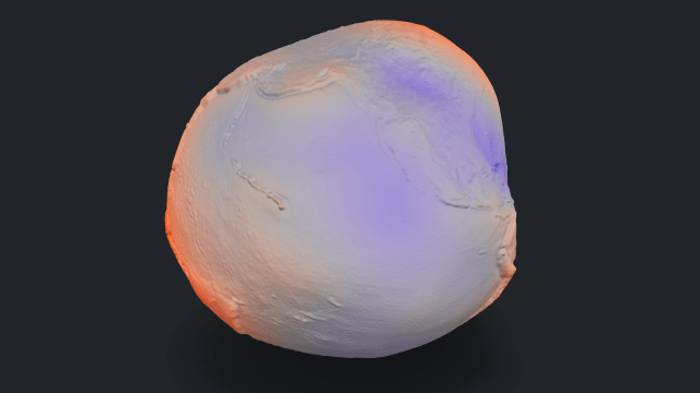
NASA has released an image showcasing Earth’s uneven surface, which is ten thousand times more exaggerated than its actual shape. This visualization does not represent a groundbreaking discovery, as scientists have known about the Earth’s lumpy nature for a long time. However, the image offers a fresh perspective on the subject.
The model used in this image is a geoid, which represents the shape the ocean surface would take if the entire planet were covered by water and only influenced by gravity. This contrasts with the oblate spheroid model, which is a smoother, geometrically accurate representation of the Earth, accounting for its rotation and the resulting equatorial bulge and polar flattening.
The geoid is created using data from over a billion measurements gathered over 15 years by various satellites, including NASA’s GRACE mission and the European Space Agency’s GOCE. The geoid’s high point is 85 meters (279 feet) above average sea level, while its lowest point is 106 meters (348 feet) below, located south of India. This means the difference between the highest and lowest points on the geoid is only 191 meters (627 feet), which could fit inside the tallest monument in the U.S., the Gateway Arch in St. Louis.
Despite the modest variations in the geoid, the lumpiness is still notable. This unevenness is caused by variations in Earth’s density, which is influenced by factors such as rock composition, mountain ranges, and ancient tectonic plates. Some areas have denser subsurface material, like basalt or peridotite, which exerts a stronger gravitational pull, causing subtle mounds on the geoid. Conversely, areas with lighter crustal material, such as sedimentary rocks or salt domes, lead to shallow basins on the geoid.
In summary, the geoid represents an equipotential surface, a theoretical level based on sea level, where every point has the same gravitational potential. Although the geoid’s variations are relatively minor compared to Earth’s tallest mountains or deepest trenches, they are still significant enough to affect GPS measurements, demonstrating the complex nature of our planet’s gravity field.
Written by urgent.news from Big Think's reporting — not their text. Machine-written — may contain errors; check the original before relying on it.
This story
This is one outlet's version. Read the fullest account.
- 25 years ago, a NASA astronaut captured this haunting photo of the 9/11 attacks — Earth from space livescience.com
- ‘Star Trek’ and NASA have intertwined legacies – the show championed diversity and inspired generations of real space scientists theconversation.com
- On this day in space! Sept. 8, 2004: NASA's Genesis spacecraft crashed in the Utah desert, shattering its samples of solar wind particles from the sun space.com