Reducing Uncertainty in Groundwater Models Using Airborne Geophysics
Scientists present a probabilistic framework for exploiting airborne geophysical data for groundwater model parameterization and apply it to the Scott River aquifer system in Northern California.
Groundwater models are essential tools for addressing various water resource issues, yet they struggle to accurately parameterize due to the limited availability of subsurface data. Geophysical data can assist in this process by offering proxy measurements of hydraulic properties, which can provide a detailed spatial dataset. The use of airborne geophysical surveys has gained traction in this context, as they can reveal the spatial variability of an entire aquifer system.
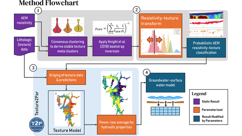
However, there is limited understanding of how to effectively integrate airborne geophysics models of subsurface electrical resistivity with borehole data to create hydraulic structure models over large areas, while accounting for the uncertainty in resistivity-lithology relationships.
In a recent study published in Water Resources Research, Scantlebury and Harter [2026] introduce a novel method for deriving hydraulic structure models from the combination of airborne electromagnetic data and borehole data, recognizing the inherent uncertainty in the relationship between resistivity and lithology. They demonstrate how these derived models can be incorporated into groundwater models, using the Scott Valley aquifer system as a case study.
By applying this probabilistic multi-texture framework, the authors suggest that this approach could significantly improve the utilization of large-scale geophysical data for reducing the predictive uncertainty of groundwater models.
Written by urgent.news from Eos's reporting — not their text. Machine-written — may contain errors; check the original before relying on it.