High-orbit satellites could light the way for travel to the moon
Acting as cooperative optical beacons, the satellites could provide GPS-like navigation and communications support for spacecraft operating across cislunar space.
In cislunar space, space missions often struggle with navigation due to the lack of a reliable positioning service comparable to Earth's GPS. NASA's Deep Space Network (DSN) provides accurate but limited navigation assistance, but its ground-based nature and limited separation between sites pose challenges for precise orbit determination in cislunar space.
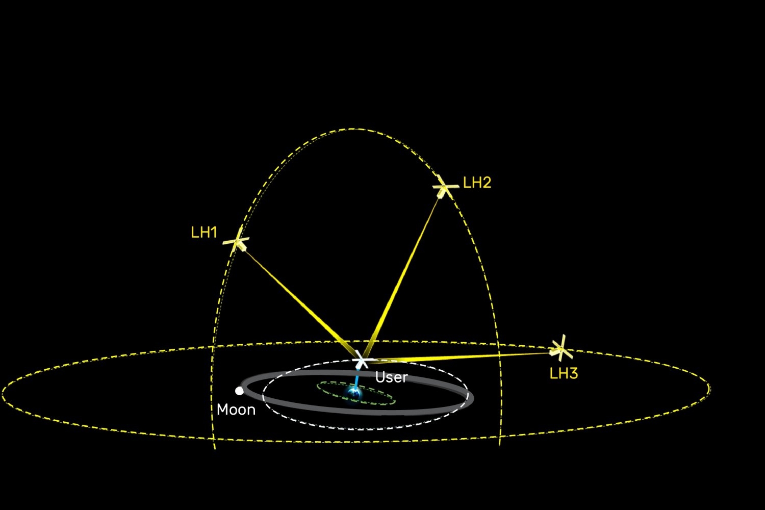
Furthermore, DSN requires user spacecraft to actively emit signals, while GPS passively sends data. MIT Lincoln Laboratory's Laser Communications Group and Advanced Capabilities and Technologies Group are developing a novel concept called LightHOUSE to address these issues. LightHOUSE would employ a fleet of satellites positioned in high-altitude orbits to act as optical beacons that share timing and communication signals with user spacecraft.
These beacons would leverage imaging techniques against the stellar background to determine each spacecraft's precise three-dimensional position and velocity. By offering independent and timely navigation data across cislunar space, LightHOUSE could reduce the necessity for corrective maneuvers, conserve spacecraft propellant, alleviate the load on onboard navigation sensors, and alleviate pressure on existing ground-based systems.
Aaron Greenberg, a technical staff member at MIT Lincoln Laboratory, explains that the moon is gaining strategic importance for national security, and precise navigation is essential for various missions. LightHOUSE will utilize free-space optical communications—lasers—to overcome the limitations of conventional radio-frequency systems.
This concept builds upon previous NASA-sponsored laboratory work, such as NASA's TBIRD and O2O programs, as well as the Optical Time Transfer for Resilient Satellite Communications Networks project. MIT Lincoln Laboratory excels in radiation-hardened digital focal plane array technology, which will enable the sensitive receivers and star cameras required for LightHOUSE.
The beacons, placed in ultrahigh orbits (up to approximately 1 million miles), will replicate GPS signal diversity for users throughout the cislunar domain. These beacons will feature telescopes with tens-of-centimeter diameters and laser transmitters in the tens-of-watts range, while user spacecraft only need centimeter-scale apertures and tens-of-milliwatt lasers.
The primary engineering challenge lies in making this asymmetric design accessible to all potential users across the cislunar region. MIT Lincoln Laboratory aims to refine the system concept through analysis, simulations, and laboratory experiments. Ultimately, the goal is to make precise navigation beyond geosynchronous altitudes a routine, reliable, and accessible service for a wide range of users, supporting Artemis and future missions in cislunar space.
Currently, the project is funded by the undersecretary of war for research and engineering through MIT Lincoln Laboratory's internally administered sensing and communications research and development portfolio. Developing a fully operational LightHOUSE system would likely require hundreds of millions of dollars, comparable to the annual operating budget of GPS ($1.8 billion) or the cost of a single DSN dish ($85-100 million).
Written by urgent.news from MIT News Research's reporting — not their text. Machine-written — may contain errors; check the original before relying on it.