Saudis flock to new navigation app Hudhud
Standard maps are of little help when the Saudi Arabian capital, which redraws itself weekly, with closures and new interchanges outpacing the Big Tech cartographers.
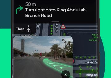
The Saudi navigation app, Hudhud, has quickly gained popularity among drivers in the Kingdom. Driving in Saudi Arabia's cities can be challenging due to the city's unique layout and frequent changes. Cities are built on wide, fast highways with tightly interwoven exits that can lead to significant delays if a driver is in the wrong lane. Standard maps prove ineffective as Riyadh's layout is redrawn weekly, with closures and new interchanges happening faster than other mapping companies can update their data.
Hudhud was developed specifically to address these challenges, functioning as a local insider's guide to navigating the city's intricacies. The app uses a fleet of camera cars to photograph streets and gather data every few meters, ensuring comprehensive coverage of even the most remote roads and towns. This detailed information allows Hudhud to provide precise, lane-by-lane guidance, complete with countdowns for roadworks, speed bumps, and traffic cameras.
Since its initial launch in Riyadh, Hudhud has expanded its coverage to encompass the entire kingdom. The app has proven particularly useful for pilgrims traveling to Mecca, guiding them through the city's historical sites and ensuring they stay on course despite the ever-changing landscape. Named after the hoopoe bird, a symbol mentioned in the Quran, Hudhud embodies the spirit of an explorer, scouting new paths and returning invaluable information to its users.
Written by urgent.news from Semafor's reporting — not their text. Machine-written — may contain errors; check the original before relying on it.